Dumnonia The Sea Kingdom of the West
Written by David Caldwell ·
1. Beginnings in Antiquity: Strabo and the Tin Trade
Long before the Romans set foot in Britain, the far west of the island was already known to the classical world. Strabo, the Greek geographer writing in the 1st century BCE, records Britain as a land rich in resources, particularly tin. This aligns with earlier accounts by Pytheas of Massalia, who voyaged to the British Isles in the 4th century BCE and may have encountered the coastal tin traders of the southwest. Tin was not just a commodity, but a strategic metal, crucial for making bronze, and it reached Mediterranean markets via Atlantic seafaring routes, possibly through Brittany, Iberia, and Gaul.
This international tin trade likely shaped the identity of the people who would later be known as the Dumnonii. Unlike their eastern counterparts who were drawn into the orbit of Rome through roads and forts, these western tribes oriented themselves toward the sea. They were part of the wider Atlantic cultural network that stretched from Cornwall to Brittany and Galicia. The Greeks and Romans knew these people by various names, but the enduring label in Roman geography was "Dumnonii", the people of the deep land.
2. The Dumnonii Tribe and Ptolemy's Map
By the 2nd century CE, Ptolemy's Geographia placed the Dumnonii in the far southwest, identifying Isca Dumnoniorum (modern Exeter) as one of their chief settlements. Yet even in Roman times, the southwest was lightly administered. No substantial villas, no Roman towns in the strict sense, only forts on the edge of the tribal zone. Archaeology supports this: the native tradition of courtyard house settlements like Chysauster and Carn Euny persisted well into the Roman period, showing adaptation without cultural surrender.
3. The Shape of Ancient Dumnonia
Defining the exact boundaries of Dumnonia has long been a subject of speculation. Classical sources suggest a region that encompassed Cornwall and Devon, but archaeological, geographical, and mythological evidence allows us to sketch a greater and lesser Dumnonia.
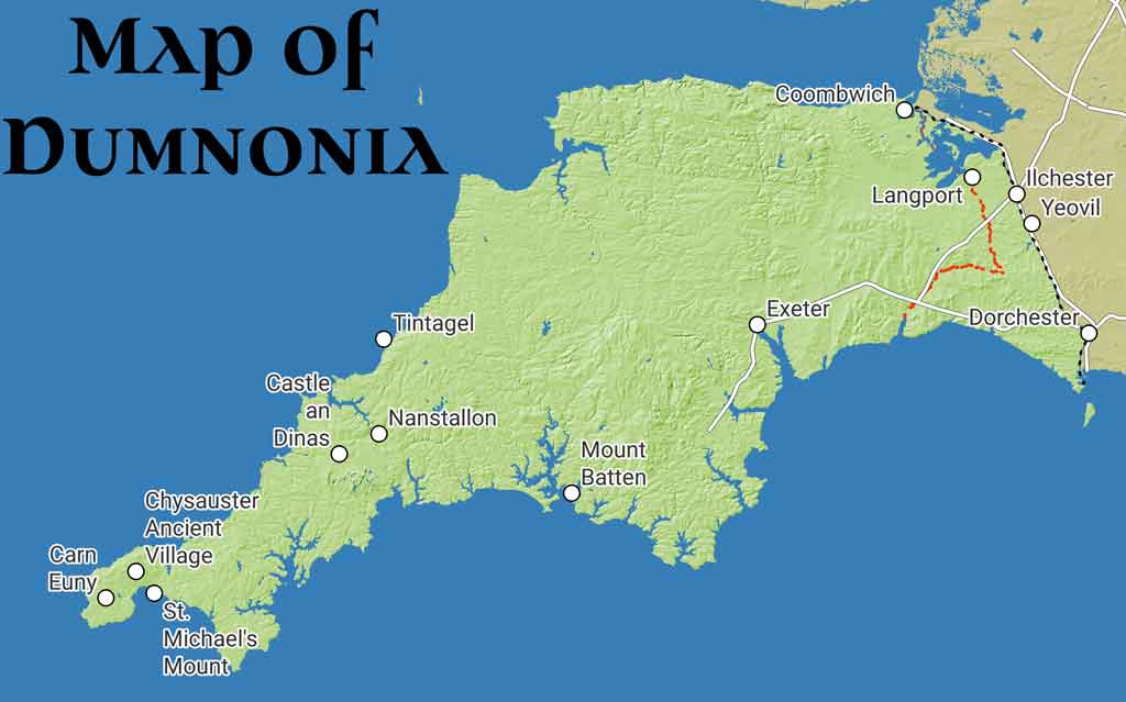
The greater Dumnonia may have extended east as far as the River Parrett and River Axe, incorporating parts of modern Somerset, including the inland sea of the Somerset Levels around Glastonbury. To the south, the River Brit could have formed part of this boundary, and to the east, a natural frontier is formed by the ridge at Broadwindsor, including Pilsdon Pen and Lewesdon Hill. These were fortified high places with commanding views, and nearby Waddon Hill housed a 1st-century Roman fort, suggesting the strategic importance of this corridor. Beyond this line, Romanised territory began in earnest.
The lesser Dumnonia, perhaps contracted in the post-Roman period, would have fallen back to the River Tamar, marking what later became the symbolic and administrative boundary of Cornwall proper. Even in the English Civil War, this line preserved Cornish identity.
4. The Seat of Power and the Sea
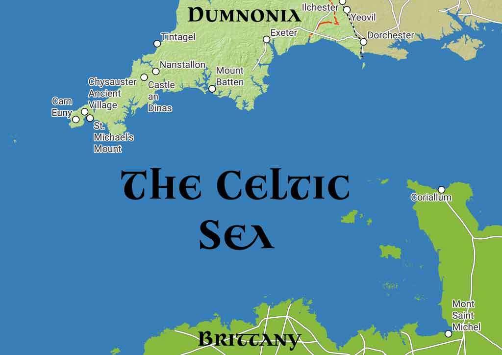
The core of Dumnonia was in Cornwall, possibly centred at Tintagel, a site with long-standing maritime links and mythic associations. From here, the kingdom oversaw the tin trade, not just with Roman Britain but across the Celtic Sea to Brittany and Iberia. Archaeological finds and migration legends suggest deep, continuous links between Dumnonia and Armorica. Some of these links were likely commercial, others sacred, and others dynastic. The post-Roman migration of Dumnonian elites to Brittany in two waves, one under Magnus Maximus and another in the 5th century, helped seed the Breton language and identity.
5. Ictis and the Global Tin Route
Diodorus Siculus, writing in the 1st century BCE, gave one of the earliest detailed accounts of the ancient tin trade in Britain. He described how the inhabitants of Belerion (modern Cornwall) were unusually courteous to foreign traders, and how they mined, smelted, and cast tin into ingots. These were then transported by carts to an island called Ictis, which was accessible at low tide. From there, the tin was shipped abroad, likely first to Brittany and then overland through Gaul.
While several locations have been proposed for Ictis, modern scholarship by Barry Cunliffe suggests Mount Batten, near Plymouth, as the most likely candidate. Supporting this theory is the discovery of a shipwreck at the mouth of the River Erme, containing tin ingots. This may reflect Bronze Age or early Iron Age maritime trade, confirming that Cornish tin travelled far, possibly as far as the eastern Mediterranean. Indeed, ancient artefacts found in Israel have been identified as containing Cornish lead.
The Reverend D. Gath Whitley, writing in 1914, argued forcefully for the identification of Ictis with a tidal island near Plymouth rather than St Michael's Mount. He pointed out that Diodorus gave a clear and literal account of the process: carts transported tin to a tidal island accessible at low tide, from which it was shipped to Gaul. Whitley challenged the association with St Michael's Mount on the grounds that it was inland, wooded, and marshy in antiquity, not matching Diodorus' description. Instead, attention has turned to Mount Batten and its surroundings in Plymouth Sound, which more accurately fit the historical and topographic details.
New research from the University of Exeter has identified a Roman road network in southwest Britain, extending from west Cornwall through Marazion and on toward the Plymouth area. This lends further weight to the theory of a coordinated overland route for tin, terminating at a coastal hub like Ictis. The infrastructure suggests a long-standing and structured system for transporting tin overland from mining districts to key embarkation points along the southern Cornish coast.
A 2023 study published in the Journal of Computer Applications in Archaeology applied advanced modelling techniques to Roman infrastructure in the southwest, highlighting probable routes that served both military and commercial interests. The analysis confirmed key corridors linking inland tin sources to coastal outlets, many aligning with the traditional paths toward Mount Batten and other coastal embarkation points. This complements the physical evidence and classical descriptions, affirming a regional network that underpinned Dumnonia's maritime economy.
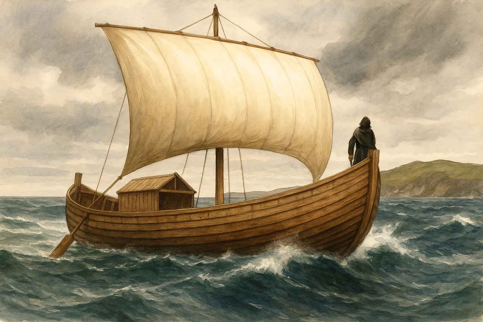
In addition to their land-based infrastructure, Dumnonian sea power was formidable. Classical sources allude to their ships as being thicker and sturdier than Roman galleys, capable of resisting ramming tactics. These descriptions are likely derived from Caesar?s account of the Veneti of Armorica in Bellum Gallicum, Book III, where he notes that ?they [the Veneti] exercise by far the most extensive authority over all the sea-coast in those districts? and that their ships were custom-built to withstand the boisterous Atlantic. The Veneti, who traded heavily with Britain, were key intermediaries and cultural cousins to the Dumnonii. It is likely that similar seagoing technology, broad-beamed, clinker-built hulls adapted for cargo and high seas, was shared or emulated across the western Celtic seaboard. Reconstructions of these vessels suggest a capability for serious maritime logistics, empowering the Dumnonii to control seaborne trade autonomously.
One such reconstruction, based on archaeological discoveries in Guernsey, is a 22-metre-long Gallo-Roman vessel exhibited by Guernsey Museums. This type of ship, visually represented by traditional reconstructions and supported by finds such as anchors and hull fragments, illustrates the scale and sophistication of pre-Roman Atlantic seafaring. As noted by naval historians (USNI article), these ships were well adapted to ocean conditions and symbolise the maritime resilience of coastal Celtic powers.
6. The Priory of Lammana: A Gateway to the Sea
One potential trading site is the Priory of Lammana near Looe. Excavations noted its location at the terminus of a ridgeway where it meets the sea, recalling Diodorus Siculus's description of tin being brought overland to trading islands. A pre-Norman chapel and an inscribed stone cross point to early religious significance, possibly built upon even older foundations.
7. A Sea Kingdom Remembered
Dumnonia was not simply a kingdom of hills and hillforts; it was a sea kingdom. Its power came from the tin beneath its soil and the maritime networks that ferried it abroad. Its culture survived Roman withdrawal because it was never fully conquered. It passed into legend in the Mabinogion and in Breton origin myths, yet its memory lingers in the hills, rivers, and coastlines of the southwest. To recover Dumnonia is to look westward, not east, to sea, not to city; to memory, not monument.
Sources
- Strabo, Geographica, 1st c. BCE
- Diodorus Siculus, Bibliotheca historica, 1st c. BCE
- Ptolemy, Geographia, 2nd c. CE
- Barry Cunliffe, ?Ictis: A Prehistoric Tin Port?, Oxford Journal of Archaeology, 1982 (DOI link)
- Historic England, Scheduled Monument Listing for Mount Batten Fortified Outpost (List Entry 1017598)
- Heritage Gateway, Waddon Hill Roman Fort Project
- University of Exeter, Roman Road Network Research, 2024
- Lockyear et al., "Predictive Modelling and the Roman South West", Journal of Computer Applications in Archaeology, 2023 (DOI: 10.5334/jcaa.109)
- Wikipedia: History of Brittany, Mining in Cornwall and Devon, Ictis, Veneti (Gaul)
- Cornwall Heritage Trust: Timeline of Roman Cornwall
- Florence of Worcester (cited in discussions of Dumnonian-Breton migration)
- Rev. D. Gath Whitley, ?The Ictis of Diodorus?, 1914
- Julius Caesar, Commentarii de Bello Gallico, Book III
- Guernsey Museums: Gallo-Roman Ship Reconstruction
- USNI: "The Veneti: Pre-Roman Atlantic Sea Power", Naval History Magazine, April 1989
This Topic
Celtic Britain, Sacred Landscapes and Lost Kingdoms
Sacred places, old kingdoms, borderlands, Atlantic routes, and the landscapes where memory, myth, and history overlap.
View Topic PageMore in this Topic
12 March 2026
Saint Piran of Cornwall26 October 2025
Elmet A Brittonic Kingdom and Enclave Between Rivers and RidgesLatest Posts
27 March 2026
Hot Cross Buns: History, Origins & FolkloreDiscover the fascinating history of hot cross buns - from pagan offerings and Greek sacred bread to Chelsea bun houses and Good Friday folklore. Explore 2,000 years of spiced bread tradition.
22 March 2026
What Does "Ne'er Cast a Clout Till May Be Out" Actually Mean?Is it about the month of May or the hawthorn flower? And what on earth is a clout? We dig into 170 years of British newspapers to finally answer one of folklore's most argued questions.
20 March 2026
The White Hart: The Ancient Legend Behind Britain's Most Common Pub SignFrom Greek mythology to medieval forest law, the white deer haunted the British imagination for centuries. Discover the real history behind the legend of the White Hart — royal badge, supernatural omen, and elusive quarry of the soul.
13 March 2026
Why Is a Horseshoe Lucky? The Surprising History Behind the World's Most Universal CharmThe horseshoe has been nailed above cottage doors, cathedral gates, and battleship masts for centuries. Discover the ancient beliefs in iron, the crescent moon, and the sacred horse that made it the world's most enduring good luck symbol.
12 March 2026
Saint Piran of CornwallPiran - patron saint of Cornwall, tin miners and the Cornish flag — from Irish origins to the buried oratory's remarkable 2014 excavation.
10 March 2026
Clare Island - Isle of Storms, Pirates and Naturalists: A History in Newspaper Voicesiscover the fascinating history of Clare Island, off the coast of Mayo - from the piratical legend of Grace O'Malley and bitter land disputes to a landmark natural history survey, told through contemporary newspaper voices spanning 1863 to 1986.