The Invisible Threads: A Cultural and Historical Journey Through Ley Lines
Written by David Caldwell ·
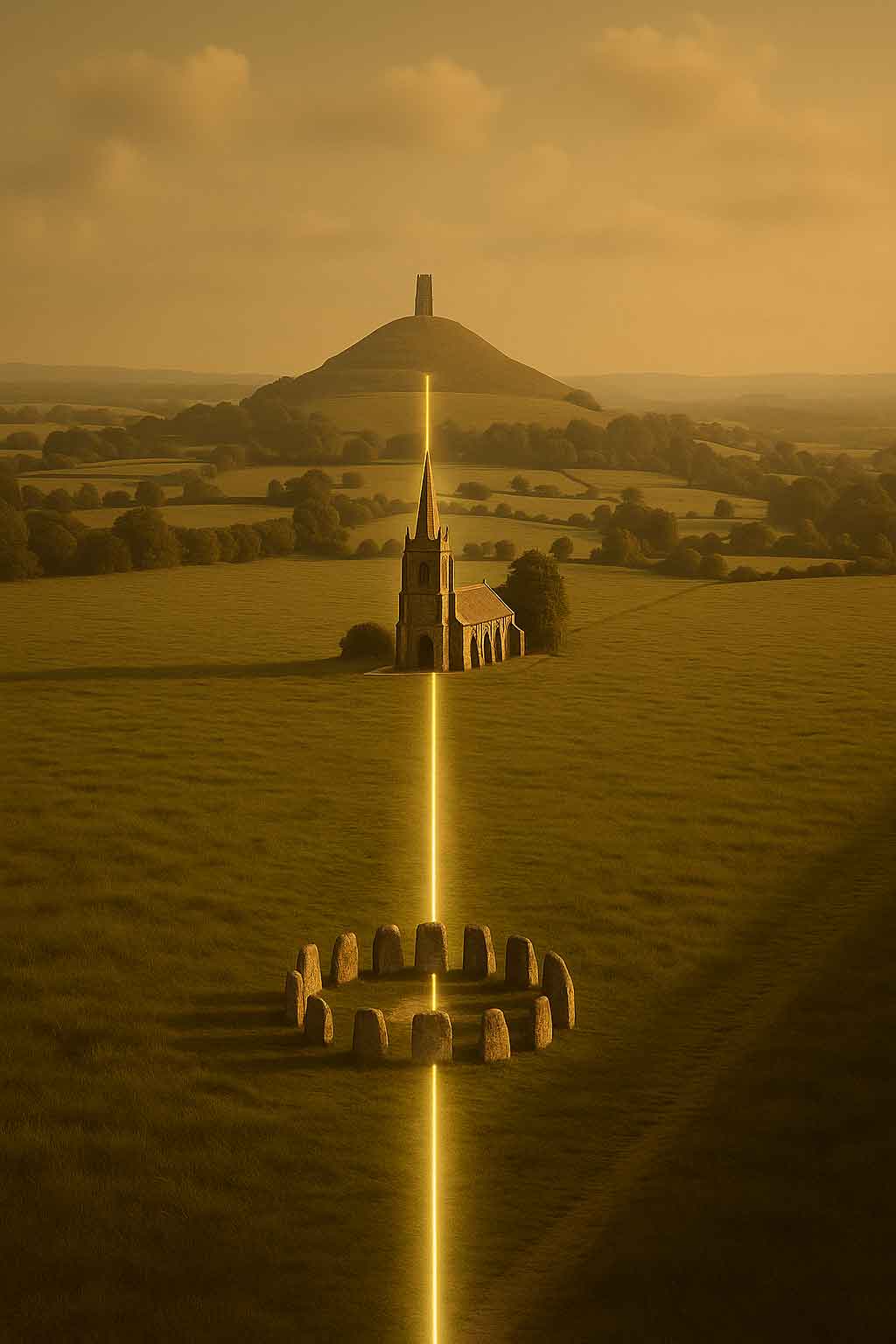
Sacred Landscapes and the Geometry of the Ancients
Sacred landscapes have been buried beneath churches, destroyed by the plough, lost to gravel extraction, or built over by our ever-expanding towns and cities.
What remains are isolated survivors, stone circles, burial mounds, and forgotten markers, perched on hilltops or standing at ancient crossroads. With the larger picture obscured or erased, our pattern-seeking minds take over. We begin to join the dots with lines, tracing imagined or rediscovered alignments across the land.
These lines, often called ley lines, have long captured the imagination. Emerging from the intersection of archaeology, folklore, and mysticism, they offer a tantalising glimpse into the possibility of a lost system of landscape geometry?one that connected sacred sites with precision, purpose, and power.
In 1921, a Herefordshire antiquarian named Alfred Watkins stood atop a hill near Blackwardine and experienced a vision that would redefine the British landscape for generations. He claimed to see a network of ancient straight tracks criss-crossing the countryside, threading through prehistoric mounds, standing stones, old churches, and hilltops. He called them "ley lines" and proposed that they were remnants of a forgotten infrastructure used by ancient peoples to navigate or mark sacred geographies. His book The Old Straight Track became the cornerstone of modern ley line theory, sparking both fervent belief and scientific scepticism.
Pre-Roman Pathways and the Foundations of Alignment
Even before Watkins, Roman engineers observed that their roads often followed existing straight tracks across Britain. These older tracks, sometimes called "green roads" or "corpse roads," were often remarkably direct, linking high places, stone circles, and barrows. In Somerset, for example, many Roman roads run atop these ancient alignments, and in Sussex and Shropshire, researchers have walked the land and verified straight-line connections between Iron Age sites, medieval churches, and even modern buildings. These patterns suggest that Britain once possessed a pre-Roman network of trackways possibly used for spiritual processions, trade, or seasonal migrations.
Some scholars believe the trackways had astronomical or ceremonial importance. David Stanley of Wanstrow described how sites such as Temple Copse, Cole Hill, and Burrow Mump in Somerset seem aligned in a ritual pattern, with beacons or churches marking nodes in an ancient web. A pilgrimage recounted in the 1970s from St Michael's Mount to Glastonbury followed a series of such aligned St Michael churches, suggesting a long-standing connection between ley lines and the veneration of landscape.
The Emergence of Sacred Geometry and the Terrestrial Zodiac
By the mid-20th century, ley line theory evolved beyond Watkins' utilitarian explanation and embraced more mystical dimensions. Writers like John Michell and Anthony Roberts explored the concept of terrestrial zodiacs: vast land-based star maps allegedly marked by natural features and ancient sites. The Glastonbury Zodiac, first proposed in the 1930s and elaborated by a number of esoteric authors, is perhaps the most famous. It overlays the Somerset landscape with immense representations of zodiac signs, said to be outlined by rivers, hedgerows, and paths.
Further north, John Billingsley identified a similar phenomenon in West Yorkshire, which he dubbed the Hebden Bridge Zodiac. He later travelled to Japan to investigate comparable geomantic traditions and discovered that some Japanese researchers had been exploring their own ancient site alignments.
Ley Lines in Japan: A Cross-Cultural Connection
In the early 1990s, Billingsley lived for several months in Osaka, where he connected with Japanese scholars interested in prehistory and sacred geography. He reported the existence of "leyjins", ancient Japanese alignments of temples, shrines, and megalithic sites, that mirrored the British fascination with straight lines and spiritual geography. Some of these lines appeared to connect Shinto shrines and burial mounds, forming geometric patterns reminiscent of British ley theories. Though Japanese archaeology traditionally focused on the past 2,000 years, there was growing interest in earlier sacred landscapes and their possible connections to energy or cosmological design.
Dowsing, Energy, and the Invisible Landscape
While many scientists dismiss ley lines as coincidental or imaginary, some researchers have attempted to measure them using dowsing rods and electromagnetic instruments. Dr. J. Havelock Fidler, an agricultural scientist, used electrostatic field meters to record energy anomalies at standing stones and Roman sites in Sutherland. He claimed that charged stones could be distinguished from uncharged ones and suggested that negative electrostatic fields might explain the sensations reported by dowsers.
David Cowan of Crieff in Scotland went further, mapping a hexagram of energy currents around his hometown. He linked this geometry to Masonic and sacred symbols, identifying alignments between churches, ancient crosses, and hillforts. His work echoed earlier suggestions that ley lines form part of a hidden energetic grid, recognised by ancient builders and preserved in folklore.
From Sacred Paths to Modern Myths
Ley lines have also been associated with darker folklore. A tabloid report once linked the town of Coggeshall in Essex, described as the "murder capital of Britain", to the intersection of two major ley lines. Ghost sightings, poltergeist activity, and even mysterious road gradients like the Electric Brae in Ayrshire have all been ascribed to earth energy fields. Lionel Stanbrook of the Society of Ley Hunters noted that many traditional sightings of headless horsemen and black dogs occur along ancient trackways, often coinciding with corpse roads or burial paths.
Despite the scepticism, ley lines continue to fascinate because they offer an alternative way of reading the landscape. They weave together archaeology, folklore, spirituality, and geography into a holistic framework that transcends modern divisions of knowledge. Whether seen as relics of prehistoric navigation, channels of earth energy, or projections of the human imagination onto the land, ley lines persist as one of the most enduring and mysterious aspects of Britain's sacred geography.
Sources referenced:
- Alfred Watkins, The Old Straight Track
- David Stanley, Somerset Guardian (1974)
- John Michell, View Over Atlantis
- John Billingsley, Hebden Bridge Zodiac research
- Anthony Roberts (ed.), Glastonbury: Ancient Avalon ? New Jerusalem
- David R. Cowan, letters on Crieff hexagram
- Dr. J. Havelock Fidler, Ley Lines: Their Nature and Properties (reviewed by A. C. McKerracher)
- Experience Sussex magazine (2002)
- Assorted local newspaper clippings from Shropshire, Essex, Perthshire, and West Yorkshire
This Topic
British Folklore, Superstition and the Uncanny
Ghosts, omens, witch-lore, monsters, charms, strange weather, and the persistent afterlife of folk belief.
View Topic PageMore in this Topic
7 March 2026
The Wandering Fire - A History of Ball LightningLatest Posts
27 March 2026
Hot Cross Buns: History, Origins & FolkloreDiscover the fascinating history of hot cross buns - from pagan offerings and Greek sacred bread to Chelsea bun houses and Good Friday folklore. Explore 2,000 years of spiced bread tradition.
22 March 2026
What Does "Ne'er Cast a Clout Till May Be Out" Actually Mean?Is it about the month of May or the hawthorn flower? And what on earth is a clout? We dig into 170 years of British newspapers to finally answer one of folklore's most argued questions.
20 March 2026
The White Hart: The Ancient Legend Behind Britain's Most Common Pub SignFrom Greek mythology to medieval forest law, the white deer haunted the British imagination for centuries. Discover the real history behind the legend of the White Hart — royal badge, supernatural omen, and elusive quarry of the soul.
13 March 2026
Why Is a Horseshoe Lucky? The Surprising History Behind the World's Most Universal CharmThe horseshoe has been nailed above cottage doors, cathedral gates, and battleship masts for centuries. Discover the ancient beliefs in iron, the crescent moon, and the sacred horse that made it the world's most enduring good luck symbol.
12 March 2026
Saint Piran of CornwallPiran - patron saint of Cornwall, tin miners and the Cornish flag — from Irish origins to the buried oratory's remarkable 2014 excavation.
10 March 2026
Clare Island - Isle of Storms, Pirates and Naturalists: A History in Newspaper Voicesiscover the fascinating history of Clare Island, off the coast of Mayo - from the piratical legend of Grace O'Malley and bitter land disputes to a landmark natural history survey, told through contemporary newspaper voices spanning 1863 to 1986.