Unearthing the Boundary with Dumnonia: Britain's Last Stand
Written by David Caldwell ·
Introduction
In the twilight of Roman Britain and the dawn of the Anglo-Saxon era, the West Country stood apart. While the eastern regions of Britannia yielded to Germanic rule, the rugged hills, river valleys, and coastal trade ports of the southwest harboured a tenacious, post-Roman kingdom: Dumnonia. Centered on Cornwall and Devon, but with influence stretching into modern Somerset and Dorset, Dumnonia retained its Celtic identity long after Rome?s legions had departed. This article traces archaeological finds, place-names, landscape analysis, and early historical sources to argue for a broader, more defensible eastern frontier of Dumnonia, a last redoubt of British resistance.
To read more about the Kingdom of Dumnonia Click Here
The Map: Reconstructing the Ancient Landscape
The map included in this article reconstructs the possible eastern frontier of Dumnonia using modern topography and archaeological evidence. A Digital Elevation Model (DEM) was employed to highlight the ancient wetlands that once defined the landscape, particularly the Somerset Levels. These wetlands, now drained, would have formed a formidable inland sea stretching from Brent Knoll to Langport and southward toward the Poldens. In this map:
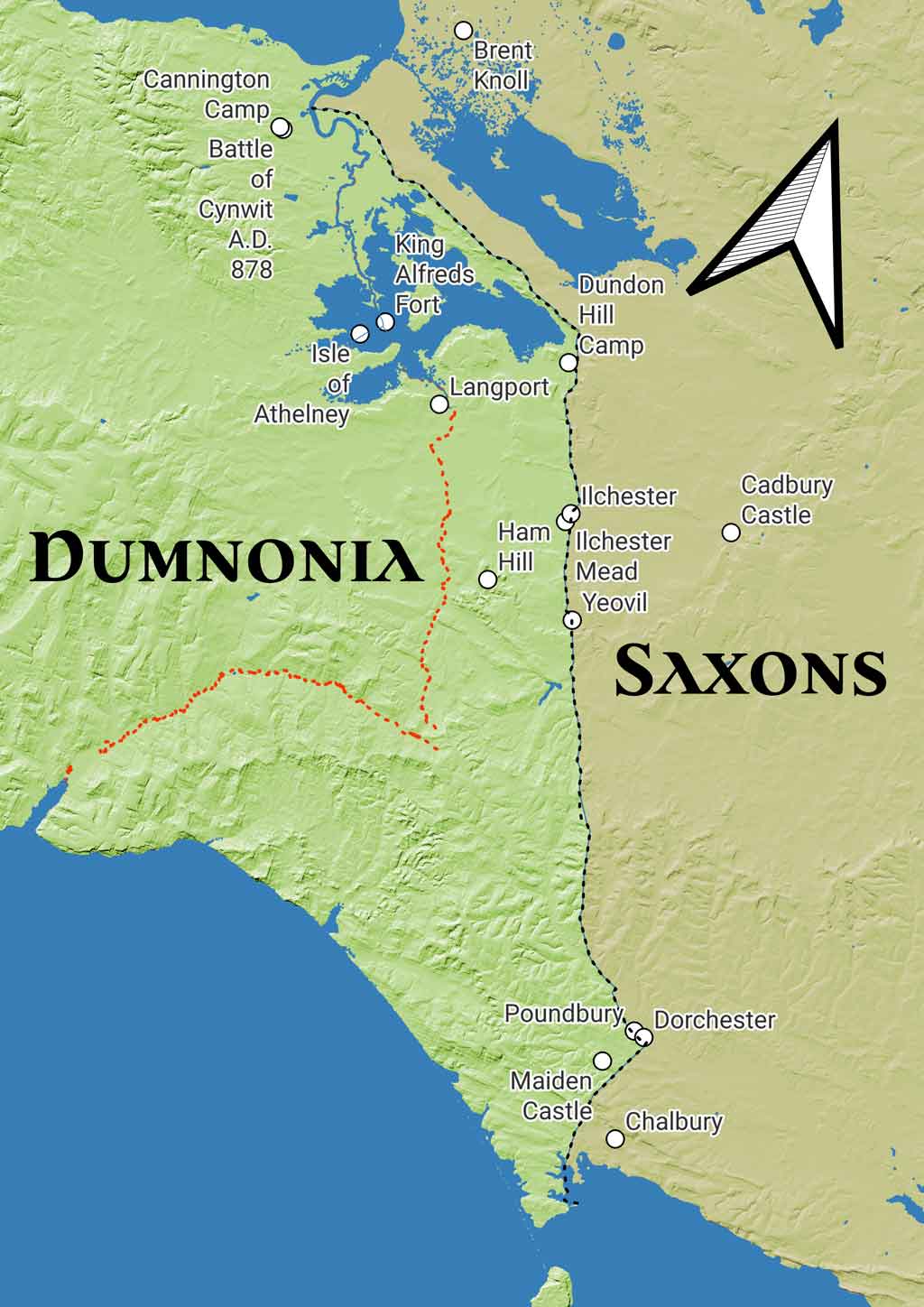
- Blue areas show the ancient waterways and lowlands that would have been tidal or seasonally flooded.
- Dashed red lines suggest a plausible hard frontier following the rivers Axe and Parrett.
- Black dashed lines trace the proposed boundary formed by Roman roads running from Portland to Dorchester and Ilchester to Polden Hills and beyond.
- White dots mark key hillforts, Roman towns, and sites of strategic importance.
This visual representation argues for a practical boundary based on terrain: a defensible frontier backed by marshland and anchored by forts such as Ham Hill, Cadbury Castle, and Maiden Castle. The western side of the line would be Dumnonia; the east, Saxon Wessex.
The Natural Border: Rivers and Marshes
The Parrett and Axe rivers likely defined the natural extent of Dumnonia to the northeast. These rivers, combined with the inland sea formed by the Somerset Levels, created a natural defensive line against encroaching Saxon settlers. In the early medieval period, the levels were likely impassable in winter and treacherous year-round without local knowledge. This landscape isolated key British strongholds such as Glastonbury Lake Village, Brent Knoll, and Langport.
The Role of Roman Infrastructure
The eastern boundary shown in the map closely follows the line of Roman roads from Ilchester (Lindinis) to Dorchester (Durnovaria). These roads mark the advance of Roman control, and later, Saxon migration, but may have formed a hard boundary beyond which Romanisation was resisted. Sites like Ham Hill, Maiden Castle, and Cadbury Castle retained their importance through the post-Roman period.
Roman finds near Pawlett, including a coin of Constantine I (dated to 337 AD), and the crossing at Combwich Passage, support the argument that trade and settlement persisted into the late Roman and sub-Roman periods. These locations line up with ancient crossing routes to the Polden Hills, another area with strong archaeological continuity.
Salt and Tin: Economic Lifelines
Roman and post-Roman activity in the region was not only defensive but economic. The Polden Hills, as reported in a 1942 article by St. George Gray, were a major site of salt extraction and Bronze Age hoards. This was not a backwater, it was an industrial zone, strategically positioned between sea and upland. Similarly, Cornwall?s tin, vital to Roman and early medieval economies, gave Dumnonia international significance.
A Patrol Along the Frontier: A Semi-Fictional Glimpse
From a high vantage point on Verne Hill on the Isle of Portland, a group of mounted Britons prepare for patrol. The site is ancient, possibly a Roman Saxon Shore fort, perhaps a hillfort, maybe a lookout post, but its commanding views across the Channel and coast are undeniable. As the sun rises over Jordan Hill, illuminating a ruined pagan temple, Owain, the patrol's leader, reflects. "The pagan sun rises in the East," he murmurs, "but it is setting on the faithful in the West."
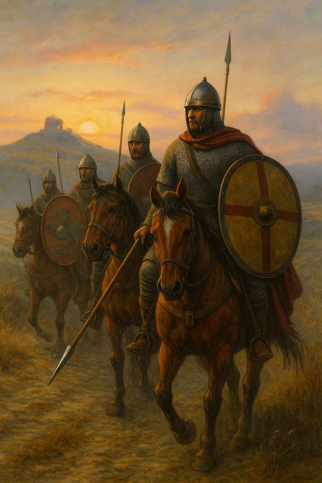
The riders, armoured in mismatched chainmail and carrying spears, depart under the rising light. A sail glints offshore, a cargo vessel, likely bound for Armorica, the land now known as Brittany. A sanctuary for Britons seeking safety.
Owain leads them across the causeway toward the mainland. They skirt Radipole Lake, once tidal, deep, and Roman-used as a shipping port, and cross the River Wey. Climbing the ancient Dorchester Road, they ascend Ridgeway Hill and pass silent round barrows, relics of their ancestors. At Maiden Castle, smoke rises from roundhouses behind ramparts; life continues amid ruins.
In Durnovaria, the Roman city of Dorchester, aqueducts still run and paved roads remain intact. They pause to resupply, water their horses, and ride out via the northern gate. At a crossroads they find the road barricaded, baskets of stone and earth hastily dumped to block a Saxon route. Signs of recent movement put the riders on edge.
Through Yeovil, a Roman station with farmers and artisans, they press on to Ilchester (Lindinis). Owain exchanges news with a trader who claims to have once owned a hoard now buried again due to Saxon raids, possibly the famed Polden Hill Hoard. The trader, wizened and bitter, warns them that many are leaving the land.
Heading northwest, the patrol climbs onto the Polden Hills, a strategic Roman road above the wetlands. Inland lakes glimmer to either side. A local farmer offers water and recounts how just two summers prior he fled a Saxon raid, hiding on Dundon Hill. The patrol presses on through insect-thick marshland. The once-proud road becomes a rough track.
Near Combwich, they cross the Parrett River at low tide, splashing over the stony ford. The ancient Combwich Passage, used since Roman times, links to the ridge road on the Polden Peninsula , the artery between salt fields, villas, and trade ports.
As they reach the hill of Cannington, known in later chronicles as Cynwit, they see the old ramparts rising. Dismounting, Owain and his men are greeted by the garrison commander, eager for news from Portland. The frontier may be holding, but the strain is growing.
The Last Redoubt: Dumnonia's Survival
By the time of the Battle of Cynwit (878 AD), the borderlands shown in the map had become the contested frontier of Wessex and what remained of British rule. King Alfred?s refuges at Athelney and Langport show how this landscape continued to shape events long after the Roman departure.
Conclusion: A Boundary Reconsidered
The boundary of Dumnonia was never fixed, it ebbed and flowed with military, economic, and environmental pressures. But the map presented here offers a compelling reconstruction: a defensible, strategic line backed by rivers and marshes, extending from the Dorset coast to the Somerset Levels. The archaeology, from salt pans and hoards to hillforts and hidden crossings, supports the theory of a frontier that held for centuries.
This was not a line on a map. It was Britain?s last stand.
This Topic
Celtic Britain, Sacred Landscapes and Lost Kingdoms
Sacred places, old kingdoms, borderlands, Atlantic routes, and the landscapes where memory, myth, and history overlap.
View Topic PageMore in this Topic
12 March 2026
Saint Piran of Cornwall26 October 2025
Elmet A Brittonic Kingdom and Enclave Between Rivers and RidgesLatest Posts
27 March 2026
Hot Cross Buns: History, Origins & FolkloreDiscover the fascinating history of hot cross buns - from pagan offerings and Greek sacred bread to Chelsea bun houses and Good Friday folklore. Explore 2,000 years of spiced bread tradition.
22 March 2026
What Does "Ne'er Cast a Clout Till May Be Out" Actually Mean?Is it about the month of May or the hawthorn flower? And what on earth is a clout? We dig into 170 years of British newspapers to finally answer one of folklore's most argued questions.
20 March 2026
The White Hart: The Ancient Legend Behind Britain's Most Common Pub SignFrom Greek mythology to medieval forest law, the white deer haunted the British imagination for centuries. Discover the real history behind the legend of the White Hart — royal badge, supernatural omen, and elusive quarry of the soul.
13 March 2026
Why Is a Horseshoe Lucky? The Surprising History Behind the World's Most Universal CharmThe horseshoe has been nailed above cottage doors, cathedral gates, and battleship masts for centuries. Discover the ancient beliefs in iron, the crescent moon, and the sacred horse that made it the world's most enduring good luck symbol.
12 March 2026
Saint Piran of CornwallPiran - patron saint of Cornwall, tin miners and the Cornish flag — from Irish origins to the buried oratory's remarkable 2014 excavation.
10 March 2026
Clare Island - Isle of Storms, Pirates and Naturalists: A History in Newspaper Voicesiscover the fascinating history of Clare Island, off the coast of Mayo - from the piratical legend of Grace O'Malley and bitter land disputes to a landmark natural history survey, told through contemporary newspaper voices spanning 1863 to 1986.